EDEN / Autonomous Blimps / Environment Perception / DEM from Stereovision
 [ People Involved ] [ Related Publications ]

Yet another page under construction...

A video illustrating the SLAM approach

(This video is in MPEG-4 format. It can be played with Quicktime 6 or mplayer).
Download preview Download Download
(320x240, 15fps, 8.4 Mo) (480x360, 15fps, 38.6 Mo) (640x480, 15fps, 82.5 Mo)


(1 min 13 sec sequence - no sound)

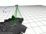
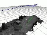
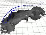
This movie shows the building of a digital elevation map during a tethered flight over the garden and parking of the lab. The perceived landmarks are shown as ellipsoids, whose size diminishes when Karma is flying over an already mapped area.

[Jung 2003] [Lacroix 2001e] [Lacroix 2002a]

Related Publications

[Jung 2003]  [related pages] [abstract] [download] [BibTeX]  [top]

I-K. Jung and S. Lacroix. High resolution terrain mapping using low altitude aerial stereo imagery. In International Conference on Computer Vision. Nice (France), 2003.


[Lacroix 2001e]  [related pages] [abstract] [download] [BibTeX]  [top]

S. Lacroix, I-K. Jung and A. Mallet. Digital Elevation Map Building with Low Altitude Stereo Imagery. In 9th Symposium on Intelligent Robotic Systems. Toulouse (France), 2001.


[Lacroix 2002a]  [related pages] [abstract] [download] [copyright] [BibTeX]  [top]

S. Lacroix and I-K. Jung. High resolution terrain mapping with an autonomous blimp. In International Conference on Intelligent Robotics and Systems. Lausanne (Switzerland), 2002.


People Involved

Simon Lacroix, Anthony Mallet, Il-Kyun Jung.
  General Information
 About the EDEN Project
 Photo Gallery
 Videos
 People
 Publications
 Related Projects
 Job opportunities
 Intranet

  Robots
 Adam
 Lama
 The Blimp
 Dala

  Rovers Navigation
 Motion control
 Environment Perception
 Environment Modeling
 Localization
 Motion Generation
 Integration

  Autonomous Blimps
 Control
 Environment Perception
>  DEM from Stereo-vision
   DEM from Monocular Images

  Multi-Robot Cooperation
 Multi UAV coordination